Avia Maps Aeronautical Charts: Your Essential Aviation Companion
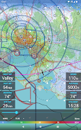
Avia Maps Aeronautical Charts is a must-have application for pilots and aviation enthusiasts globally. Whether planning a flight or navigating mid-air, this app provides comprehensive support. Downloadable offline data allows access to a vast database covering any 5x5 degree area on Earth, encompassing over 65,000 airports, 9,000 navaids, and 15,000 waypoints. Stay informed with global, high-resolution weather forecasts, including cloud cover, precipitation, and wind conditions, even without cellular service.
Prioritizing safety, the app integrates traffic information from ADS-B receivers or the SafeSky app, providing real-time situational awareness. Additional features include precise performance calculations tailored to multiple aircraft profiles and seamless data synchronization across devices. Experience the power of Avia Maps Aeronautical Charts today!
Key Features:
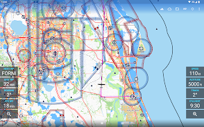
- Unmatched Aviation Data: Access detailed, user-friendly aviation charts for worldwide flight planning and in-flight navigation.
- Offline Capability: Download data for any 5x5 degree area for uninterrupted use, even in areas without cellular reception.
- Extensive Airport and Airspace Coverage: Navigate with confidence using information on over 65,000 airports, 9,000 navaids, and 15,000 waypoints globally, plus airspace data for 62 countries (excluding Antarctica).
- Global Weather Insights: Receive high-resolution weather forecasts from reputable sources like the German DWD and US NOAA, displaying cloud cover, ceiling, precipitation, and wind data for both ground and aloft conditions. Offline access is available.
- Enhanced Safety with Traffic Awareness: Integrate traffic information directly onto the map via ADS-B receivers or the SafeSky app for improved safety during flights.
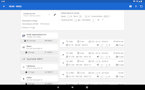
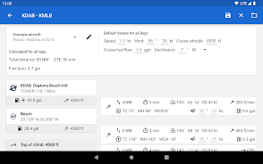
- Precise Flight Performance: Create multiple aircraft profiles and utilize accurate performance calculations considering engine type and fuel burn for optimal flight planning.
In Conclusion:
Avia Maps Aeronautical Charts provides a comprehensive and reliable toolkit for pilots and aviation enthusiasts. Its offline capabilities, extensive database, integrated weather and traffic information, and precise performance calculations make it an invaluable asset for pre-flight planning and in-flight navigation. Download the app now and elevate your aviation experience.


